The idea of the web site is to be ALL WEATHER and ALL LOCAL.
History:
After having various weather instruments through the years, in April 1999, I purchased and installed Davis Weather Monitor II hardware instruments and console. Also purchased was WeatherLink software to make it possible to view the data on a computer. Having an abundance of local weather information but unable to share with others who might find it interesting and useful seemed disappointing. Then in November 2003, a computer upgrade became available which included generating a web site, as well as sending reports to other sites.
The web page was started and continues to be a work in progress.
February 2011, the weather equipment was replaced with a new Davis Vantage Pro2 to gain newer technology, more accuracy, and additional features. Early on, when people would ask about that contraption on the roof, my wife would say, "Oh, that's Jim's Weather Station" and thus the name. Today the site is titled Weather Winchester but we've kept the old name on the page and most search engines can find the site by searching either title.
Geography:
The station is located in Frederick County approximately two miles due south of Winchester, Virginia's southern boundary. Latitude 39.100209 Longitude -078.180235 Elevation 730' Map location within the National Weather Service's Sterling Va radar can be seen here, shown as CW1500.
Equipment:
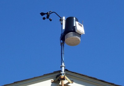
The automated weather station hardware is a Davis Wireless Vantage Pro2™ with Standard Radiation Shield and the software is a WeatherLink®, Windows, USB. The automatic rain gauge is equipped with a remote switched heater to provide immediate rain equivalent values for falling snow/sleet/freezing rain.
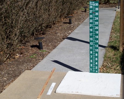
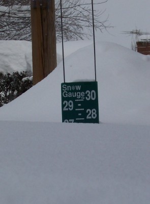
The weather instruments are continually calibrated and data quality is checked and analyzed each day here. Other equipment include a manual rain gauge used to calibrate the automatic rain gauge and to determine snow/ice melted values, and a 2'x2' white snow board with affixed over-sized half inch increments snow gauge as well as tenths inch ruler and yard stick for snow reports.
The weather equipment is mounted in a clear area on the eave of the one story house. The outdoor portion of the station consists of temperature and humidity sensors with a radiation shield to prevent sunlight from affecting the readings. The automatic rain collector measures rainfall in 100ths of an inch and has a heater to prevent the collector from freezing and to provide rain equivalent values of frozen precipitation on a real time basis. The automatic rain collector is kept in calibration by synchronizing
with the manual gauge. The wind vane is calibrated to true north using the shadow of the mid day sun. Time of mid day is determined by using the sunrise/sunset times for the station's coordinates on the date of calibration. The outdoor equipment is solar powered with storage battery and data is transmitted by radio to the indoor console.
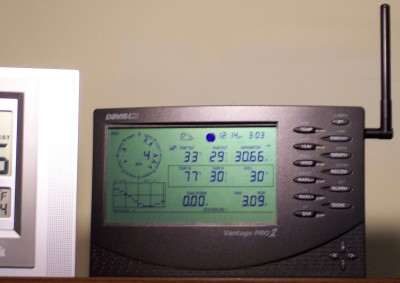
The Weather Console consists of indoor temperature and humidity sensors, barometer and radio receiver to collect the data transmitted from the outside unit. The Console processes the received data and calculates additional information such as wind chill, heat index, rain rate and daily, monthly, yearly, storm totals. This information is shown on the Console display.
The barometer is calibrated during periods of stable air pressure with the Winchester Regional Airport, 3.6 miles Northeast.
A WeatherLink module is connected to the Console. It processes the station information and links it to the computer via USB.
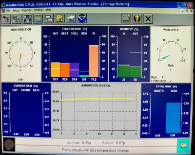
The WeatherLink computer program provides live weather information from the weather station. It continually compiles and archives daily, monthly and annual summaries and can generate charts, graphs and reports for printing or exporting. The WeatherLink computer program is also responsible for sending the half hour updates to the Weather Station web site, Weather Underground and Citizen Weather Observer Program.
The computer's clock is automatically calibrated once per hour by the NIST software program.
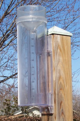
A manual rain gauge is used to check the accuracy of weather station's automatic rain collector. It's also used to melt snow, sleet and freezing rain to provide a liquid value report along with the daily precipitation reports to CoCoRaHS as shown in this <"weatheryourway.com/">report.
The outer overflow cylinder is also used for snow & ice core samples to determine water content of snow/ice on the ground.
The Snow Board is in a clear area with some wind break to reduce drifting. The board is 2'x2' with an oversized gauge for large snows. A ruler marked in tenths of an inch is used for smaller snows.
The snow storm of February 6, 2010.
Reporting:
JIM'S WEATHER STATION WEB SITE: The Weather Station program is set to automatically update the web page with current data every thirty minutes at :01 and :31. The Current Month and Current Year Climatological Summary pages are set to automatically update once per day at 12:01 am.
The Month and Annual Climatological Summaries consist of data compliled by the Weather Station since inception of the web site late in 2003. In every Annual Summary is a column titled "DEP FROM NORM". This shows each month's temperature and precipitation variation from average and is based on Winchester records dating back to 1912 (Source). WEATHER UNDERGROUND: Every five minutes updates are sent to Weather Underground's Personal Weather Stations page, and to Weather Underground's History page for this station. This station is identified as KVASTEPH2. CITIZEN WEATHER OBSERVER PROGRAM: At :02 and :32 automatic updates are sent to the Citizen Weather Observer Program here and here. This station is identified as CW1500. COCORAHS: Once per day a manual precipitation report is sent to CoCoRaHS and can be viewed on their map and is shown here. This station is identified as VA-FD-1 & Stephens City 2.2 E. WDVM-TV: Monday through Friday a brief report is phoned in to WDVM TV Channel 25 in Hagerstown to be used with their Weather Watchers' Reports and is aired at 12:30 pm. SKYWARN: Routine reports such as snow amounts are emailed to the National Weather Service in Sterling and become part of the Public Information Statements such as these, as well as other media sources. Severe or extreme weather observations are phoned to the Service on an as necessary basis. This station is identified as: 2 E STEPHENS CITY.
In 2004 status as a NWS Skywarn Spotter was aquired by attending and completing the Basics I, Basics II, Floods, Hurricanes and Winter Storms courses conducted by the National Weather Service, Sterling, Va.